First flooding; now snow?
Published 9:12 am Wednesday, January 4, 2017
Corey Williams | The Brewton Standard
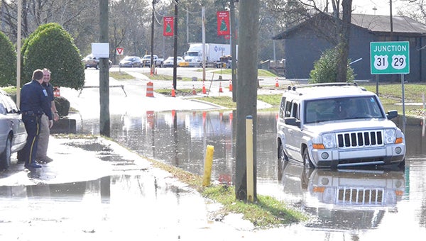
Burnt Corn Creek flood waters caused this Jeep to stall Tuesday afternoon. Police caution drivers to take all safety precautions when traveling.
Crazy weather pattern continues
After recent storms dropped nearly six inches on the Brewton area, residents may soon have to prepare for what may be end of the week snow flurries.
Heavy storms with damaging winds moved into the county Saturday evening. Through Sunday and Monday, rain continued to fall and residents worried about localized flooding.
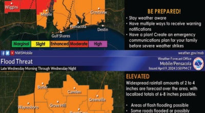
Tuesday morning, officials were watching the water at Burnt Corn Creek, specifically at MPG/Grede, where rising waters filled the employee parking lot. Operations continued without change Tuesday morning; however, officials said they are monitoring the situation. National Weather Service in Mobile forecasted the creek to crest at 16.2 feet Tuesday evening.
The NWS also issued a flood warning for Murder Creek through Tuesday evening. With a flood stage level of 22 feet, water levels reached 21.7 feet Tuesday morning. The creek was expected to continue rising to 22.7 feet today, which will prompt the closure of Persimmon and Ann Streets.
The NWS also issued a river flood warning “until further notice” for the Escambia River near Century. Monday evening totals put the river at 16 feet – one foot shy of the 17-foot flooding level. The river is expected to continue to use to near 20.6 feet by Tuesday night. The NWS noted that at 19 feet, low lying pasture floods and urged farmers to move cattle to high ground.
As the week progresses, the spring-like temperatures will give away to freezing rain.
Tonight, temperatures will plummet to 37 degrees. And while a mostly sunny sky on Thursday will warm things a bit, forecasts are predicting a 60 percent chance of rain and high of 51 and low of 31 degrees on Friday. Saturday’s daytime high is expected at 47 degrees. Coupled with a 40 percent chance of rain and a nighttime low of 26 degrees, ice is predicted for Saturday. Sunny skies are forecasted for Sunday and Monday and nighttime lows of 26 and 36 degrees respectively.
By Wednesday, the spring-like temperatures will return with a daytime high of 73 degrees and a 40 percent chance of rain.