(4 p.m. Saturday update) EMA director issues update; flood threat expanded
Published 4:52 pm Saturday, May 26, 2018
Escambia County EMA Director David Adams just released the 4 p.m. forecast for subtropical storm Alberto.
“Confidence is increasing in the accuracy of the forecast,” he said. “Please not that the area included in the flash flood watch and the area included in the extreme flash flood threat has been extended to include a large area to the north and east. This area includes most, if not all of the river and stream basins for Big Escambia Creek, Little Escambia Creek, Murder Creek, Burnt Corn Creek, and the Conecuh River. The area could possibly see 6 to 12 inches of rainfall, with localized higher amounts (maybe even double these amounts). This increased the likelihood the we will see flooding conditions on these waterways. This could mean flooded roadways.”
Adams said residents who must drive should use extreme caution.
“If water covers the roadway or bridge, turn around and find another route,” he said. “It only takes about 6 inches of fast moving water to float and move a vehicle. You cannot see what is or is not under the water. The road way, culvert or bridge may be washed away. It’s not worth the chance to try to cross it, you will endanger you, your family and the first responders that will be called to assist. Swift-water rescue is very dangerous and not always successful.”
Key points from the National Weather Service residents should know include:
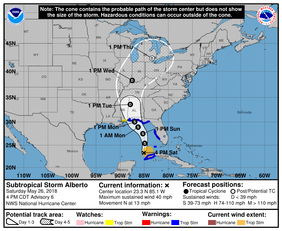
- A new circulation had formed further Norther;
- Alberto’s track shifted a bit farther east (now officially near the Alabama- Florida border region), but is still way too early to start pinning it down;
- Multi-day excessively heavy rainfall event unfolding with 6-12” closer to
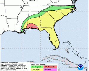
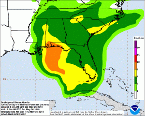
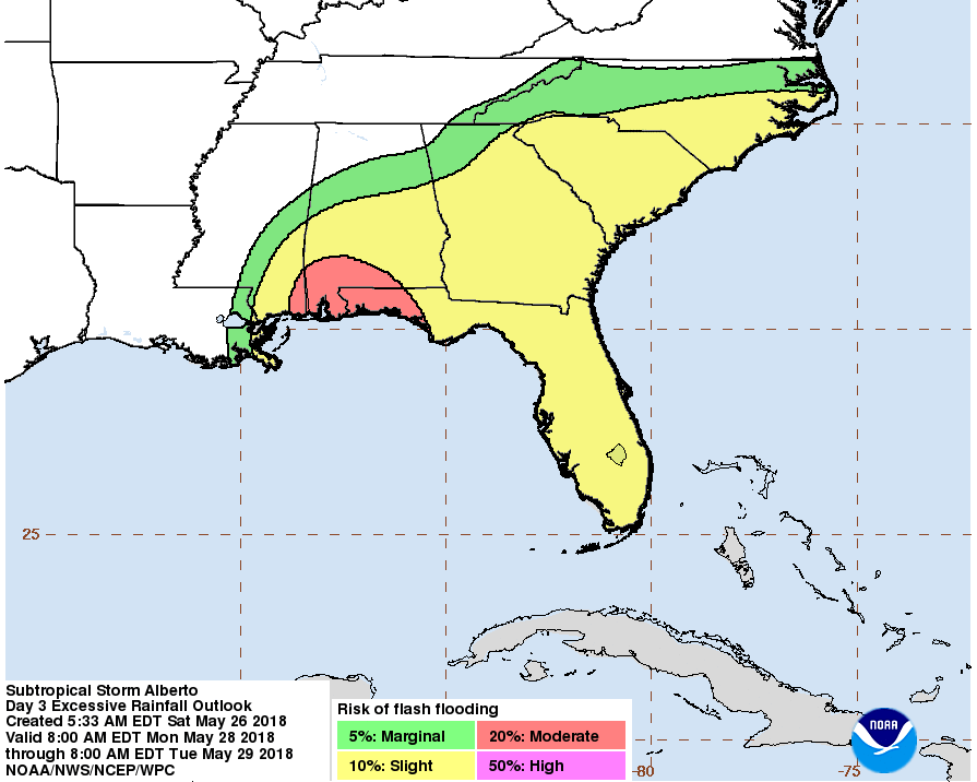

coast and 4-7” inland. Some locations could see 10-15” east of the low center.
Looking now at lowering rainfall amounts west of low center (but will not go
too far since early).
- Prolonged tornado threat due to our region being in right-front quadrant of
Alberto for almost 1.5 days.
- Lingering river flooding next week – could hamper response and recovery.
Key current observations:
- Thunderstorm activity developing around closed low center.
- However, deep convection still sheared off to east.
- Pressures falling (999 mb) and better development underway.
- Center clearly drifting more west past few hours.
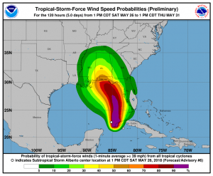
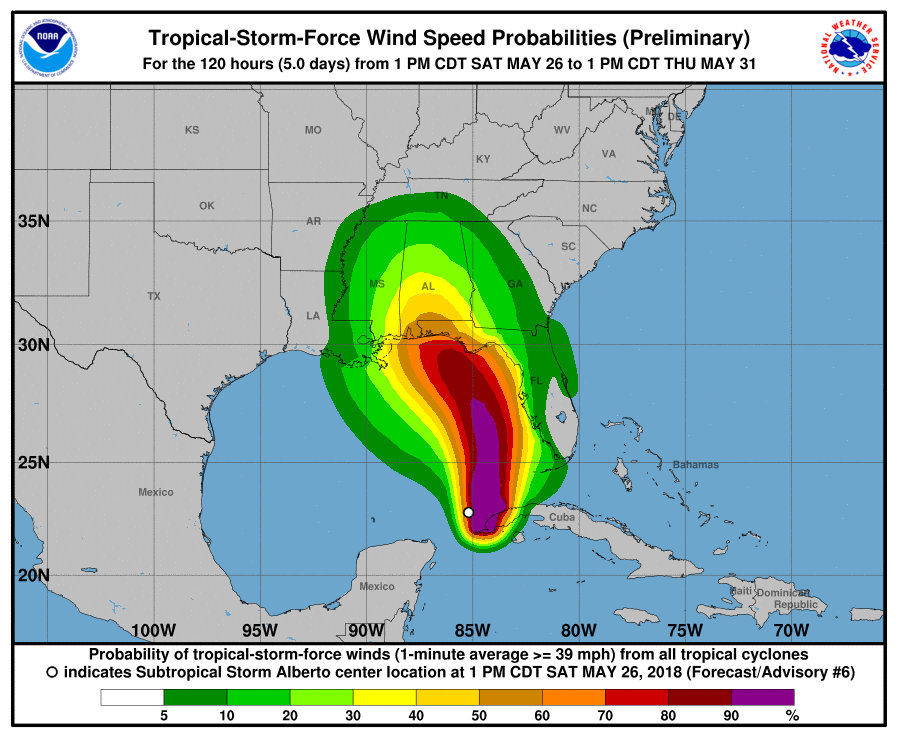
A tropical storm watch is currently in effect for the following counties
In Northwest Florida:
- Escambia
- Santa Rosa
- Okaloosa
In Southwest Alabama:
- coastal and center portions of Mobile and Baldwin counties.
The same counties are also under a storm surge watch.
NWS has issued the following evolution and impact windows:
- Midnight (Sat., May 26): Coastal water level rises begin late in the day and long period swell and high surf arriving and developing along the coast during the day
- 7 a.m., Sun., May 27: Coastal water levels continue to rise; continuous rain overspreading southern counties; water for greater than expected intensification;
- 7 p.m., Sun., May 27: Things go downhill from this point on; coastal water levels rise; winds along coast really increase overnight.
- Monday: Landfall late Monday somewhere in the Mississippi-Alabama-Florida region.
Coastal wind impacts increasing 35-45 mph sustained with higher gusts.
- Very heavy rain with flooding and isolate tornadoes.
- Tuesday: system just inland but moving very little. Likely serious flooding impacts and it transitions to depression intensity.
- Tornado threats shift inland.
- Rivers likely rising rapidly and heavy rain, flash flood threat ongoing.