Latest update (4 p.m.) on Tropical Storm Gordon
Published 3:59 pm Monday, September 3, 2018
Tropical Storm Gordon is forecast to move into the southeast Gulf ofMexico later today, and reach the central Gulf coast by late Tuesdayor Tuesday night. Gordon has the potential to bring significantrainfall amounts, flash flooding, and isolated tornadoes to the area,mainly across portions of inland southeast Mississippi, southwestAlabama, and the western Florida panhandle. Tropical storm force windsand coastal flooding impacts are also possible.
* WIND:
Protect against dangerous wind having possible significant impacts
across coastal portions of southwest Alabama and lower portions of
southeast Mississippi. Potential impacts in this area include:
– Some damage to roofing and siding materials, along with damage
to porches, awnings, carports, and sheds. A few buildings
experiencing window, door, and garage door failures. Mobile
homes damaged, especially if unanchored. Unsecured lightweight
objects become dangerous projectiles.
– Several large trees snapped or uprooted, but with greater
numbers in places where trees are shallow rooted. Several
fences and roadway signs blown over.
– Some roads impassable from large debris, and more within urban
or heavily wooded places.
– Scattered power and communications outages, but more prevalent
in areas with above ground lines.
Also, protect against hazardous wind having possible limited impacts
across the rest of inland southeast Mississippi, southwest and south
central Alabama and the northwest Florida panhandle.
* SURGE:
Protect against life-threatening surge having possible significant
impacts across coastal Alabama and coastal portions of the western
Florida panhandle. Potential impacts in this area include:
– Areas of inundation with storm surge flooding accentuated by
waves. Damage to several buildings, mainly near the coast.
– Sections of near-shore escape routes and secondary roads become
weakened or washed out, especially in usually vulnerable low
spots.
– Major beach erosion with heavy surf breaching dunes. Strong and
numerous rip currents.
– Moderate damage to marinas, docks, boardwalks, and piers.
Several small craft broken away from moorings, especially in
unprotected anchorages.
Elsewhere across portions of southwest Alabama…northwest
Florida…south central Alabama…and inland southeast Mississippi.,
little to no impact is anticipated.
* FLOODING RAIN:
Protect against locally hazardous rainfall flooding having possible
limited impacts across portions of southwest Alabama…northwest
Florida…south central Alabama…and inland southeast Mississippi..
Potential impacts include:
– Localized rainfall flooding may prompt a few evacuations.
– Rivers and tributaries may quickly rise with swifter currents.
Small streams, creeks, canals, and ditches may become swollen
and overflow in spots.
– Flood waters can enter a few structures, especially in usually
vulnerable spots. A few places where rapid ponding of water
occurs at underpasses, low-lying spots, and poor drainage
areas. Several storm drains and retention ponds become
near-full and begin to overflow. Some brief road and bridge
closures.
* TORNADOES:
Protect against a tornado event having possible limited impacts
across portions of southwest Alabama…northwest Florida…south
central Alabama…and inland southeast Mississippi.. Potential
impacts include:
– The occurrence of isolated tornadoes can hinder the execution
of emergency plans during tropical events.
– A few places may experience tornado damage, along with power
and communications disruptions.
– Locations could realize roofs peeled off buildings, chimneys
toppled, mobile homes pushed off foundations or overturned,
large tree tops and branches snapped off, shallow-rooted trees
knocked over, moving vehicles blown off roads, and small boats
pulled from moorings.
WATCHES AND WARNINGS
——————–
CHANGES WITH THIS ADVISORY:
The Storm Surge Warning has been extended eastward to Dauphin
Island, Alabama.
A Hurricane Warning has been issued from the Mouth of the Pearl
River to the Alabama-Florida Border. This warning replaces the
Hurricane Watch and Tropical Storm Warning for this area.
The Tropical Storm Warning for the Upper Florida Keys and from
Golden Beach to Chokoloskee, including Florida Bay, has been
discontinued.
SUMMARY OF WATCHES AND WARNINGS IN EFFECT:
A Storm Surge Warning is in effect for…
* Shell Beach to Dauphin Island
A Storm Surge Watch is in effect for…
* West of Shell Beach to the Mouth of the Mississippi River
* East of Dauphin Island to Navarre
A Hurricane Warning is in effect for…
* Mouth of the Pearl River to the Alabama-Florida Border
A Tropical Storm Warning is in effect for…
* Chokoloskee to Bonita Beach
* West of the Mouth of the Pearl River to east of Morgan City,
Louisiana, including Lake Pontchartrain and Lake Maurepas
* Alabama-Florida Border to Okaloosa-Walton County Line
A Storm Surge Warning means there is a danger of life-threatening
inundation, from rising water moving inland from the coastline,
in the indicated locations. For a depiction of areas at risk, please
see the National Weather Service Storm Surge Watch/Warning Graphic,
available at hurricanes.gov. This is a life-threatening situation.
Persons located within these areas should take all necessary actions
to protect life and property from rising water and the potential for
other dangerous conditions. Promptly follow evacuation and other
instructions from local officials.
A Storm Surge Watch means there is a possibility of life-
threatening inundation, from rising water moving inland from the
coastline, in the indicated locations.
A Hurricane Warning means that hurricane conditions are expected
somewhere within the warning area. Preparations to protect life
and property should be rushed to completion.
A Tropical Storm Warning means that tropical storm conditions are
expected somewhere within the warning areas.
For storm information specific to your area, including possible
inland watches and warnings, please monitor products issued by your
local National Weather Service forecast office.
DISCUSSION AND OUTLOOK
———————-
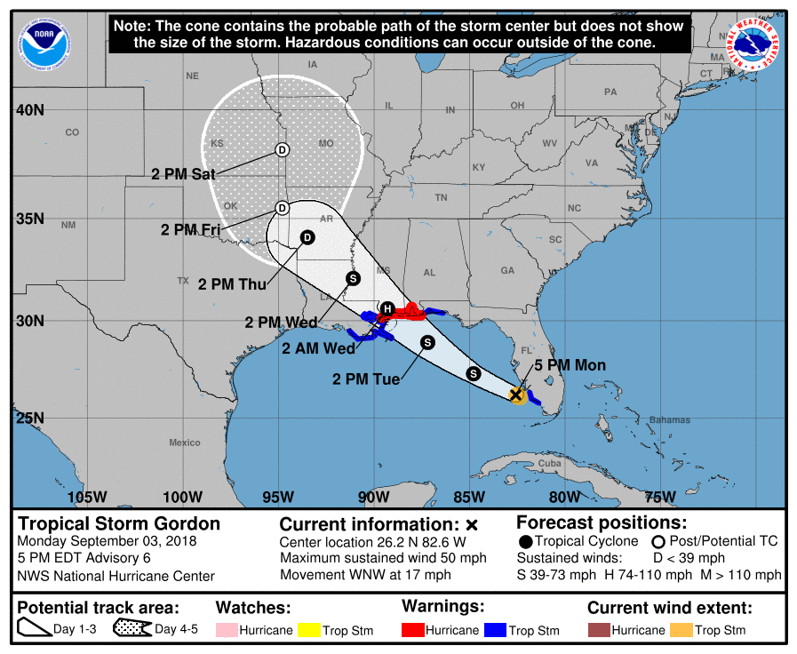
At 500 PM EDT (2100 UTC), the center of Tropical Storm Gordon was
located by NOAA Doppler weather radars near latitude 26.2 North,
longitude 82.6 West. Gordon is moving toward the west-northwest near
17 mph (28 km/h) and a west-northwestward to northwestward motion is
expected over the next 72 hours. On the forecast track, the center
of Gordon will move farther away from the southwestern coast of
Florida early this evening, and move across the eastern Gulf of
Mexico tonight and Tuesday. The center of Gordon will approach the
central Gulf Coast within the warning area late Tuesday or Tuesday
night, and move inland over the lower Mississippi Valley on
Wednesday.
Maximum sustained winds are near 50 mph (85 km/h) with higher gusts.
Gradual strengthening is forecast during the next 36 hours, and
Gordon is expected to be a hurricane when it makes landfall along
the central Gulf Coast.
Tropical-storm-force winds extend outward up to 45 miles (75 km)
from the center.
The estimated minimum central pressure is 1006 mb (29.71 inches)
based on earlier reports from an Air Force Reserve reconnaissance
aircraft.
HAZARDS AFFECTING LAND
———————-
STORM SURGE: The combination of a dangerous storm surge and the
tide will cause normally dry areas near the coast to be flooded by
rising waters moving inland from the shoreline. The water could
reach the following heights above ground somewhere in the indicated
areas if the peak surge occurs at the time of high tide…
Shell Beach to Dauphin Island, Alabama…3 to 5 ft.
Navarre Florida to Dauphin Island, including Mobile Bay…2 to 4 ft.
Shell Beach to the Mouth of Mississippi River…2 to 4 ft.
Mouth of the Mississippi River to the Louisiana-Texas border…1 to
2 ft.
The deepest water will occur along the immediate coast near and to
the east of the landfall location, where the surge will be
accompanied by large waves. Surge-related flooding depends on the
relative timing of the surge and the tidal cycle, and can vary
greatly over short distances. For information specific to your area,
please see products issued by your local National Weather Service
forecast office.
RAINFALL: Gordon is expected to produce total rain accumulations of
2 to 4 inches over the northwestern Bahamas, Florida Keys, and South
Florida through early Tuesday. Isolated maximum amounts of 8 inches
are possible over the southern Florida peninsula.
Gordon is expected to produce total rain accumulations of 4 to 6
inches over southern Alabama, southern and central Mississippi, and
southeastern and northeastern Louisiana, with isolated maximum
amounts of 8 inches through late Thursday.
These rainfall amounts may cause flash flooding.
WIND: Tropical storm conditions will continue for the next few
hours in the warning area across southwestern Florida. Tropical
storm conditions are expected within portions of the central Gulf
Coast warning area by late Tuesday, with hurricane conditions
expected late Tuesday or Tuesday night in the hurricane warning
area.
TORNADOES: A couple of tornadoes are possible through tonight
across the southern and west-central Florida Peninsula.