NWS updates weather expectations for today, Thursday
Published 11:00 am Wednesday, March 17, 2021
|
Getting your Trinity Audio player ready...
|
The National Weather Service in Mobile is continuing to update information as an expected severe weather event approaches our area here in south Alabama.
The following information was released at about 10:30 a.m. on Wednesday and highlights some concerns for the next 24 hours. The graphic attached to this post will give additional information as well.
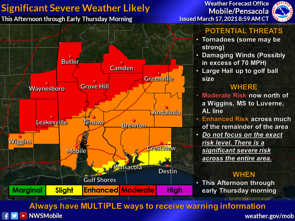
“Our confidence remains relatively high for a significant severe weather event this afternoon and tonight before the threat ends from west to east with a cold frontal passage,” NWS information stated. “All three modes of severe weather are possible, tornadoes (some strong, EF2 or higher), large hail and damaging wind gusts to 70 mph +. We have seen nothing in the data to sway original thoughts and the webinar slides that were sent yesterday, and reflect our collective current thinking on the What, When and Where aspects of this upcoming event. Now is the time to bring any final preparations to a close!”
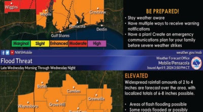
We also wanted to provide an update on the ongoing flooding situation that has developed over interior southwest Alabama.
- Flash Flooding and Overnight Forecast: The flash flooding threat will again increase this afternoon and tonight as additional convective development is likely. A Flash Flood Watch has been issued for Choctaw, northern Clarke, and Wilcox counties in Alabama, and Wayne county in Mississippi. Much of this rain will move across the same areas that have already received several inches of rainfall yesterday. Additional rainfall amounts of 1 to 3 inches will be possible across the watch area and this will exacerbate ongoing flooding conditions and possibly initiate additional areas of flash flooding.
- Severe Weather Outbreak Increasingly Likely Wednesday ThroughThursday Morning:
o This Afternoon Through Mid Evening: WHAT?: Isolated, discrete to semi-discrete supercell thunderstorm development remains possible this afternoon across the entirety of our CWA. WHEN and WHERE?: Best timing for convection to develop still appears to be after 1 PM CDT. These thunderstorms will move from southwest to northeast across the CWA through about 9 PM CDT. The environment is favorable for the production of strong tornadoes, damaging winds to 70+mph, and large hail upwards of golf ball size. The biggest question that currently exists is with respect to coverage during the afternoon and evening.
- Mid Evening and Tonight: An even more likely threat for severe weather will evolve during the late evening and overnight hours tomorrow night. WHAT?: A line/broken line of intense thunderstorms will likely be ongoing along and ahead of the front, with embedded supercell structures. WHEN and WHERE?: Best timing for this feature will likely be between 9PM to 1AM across southeastern Mississippi, 11PM to 3AM over southwestern Alabama including areas west of I-65, and 1AM to 6AM for the Florida Panhandle and southwest/south-central Alabama east of I-65. Adequate There remains uncertainty in regards to if the line remains broken or solid, which will have an impact on severe hazards\impacts. The data we continue to examine still favors a potential for strong tornadoes, damaging winds to 70mph+, and large hail to golf ball size. If the line turns out to be more congealed a larger damaging wind threat would evolve, along with a continuation for tornadoes and some instances of large hail.