Risk of severe weathering increasing
Published 11:13 am Friday, April 9, 2021
|
Getting your Trinity Audio player ready...
|
Escambia County’s Emergency Management Agency Director David Adams is urging area residents to stay weather aware as potentially severe weather approaches.
On Friday morning, Adams provided information he gained from the National Weather Service in Mobile.
“There is potential for severe weather through Saturday afternoon,” Adams said. “Please stay aware of changing and/or dangerous conditions and take appropriate actions for your safety.”
National Weather Service officials are continuing to monitor a strong line of storms headed into the area in the next several hours.
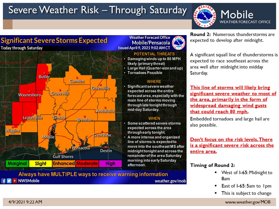
“We have taken a closer look at some things this morning and the bottom line is the severe weather risk continues to increase, especially after midnight into Saturday morning,” NWS officials said Friday morning. “The Moderate and Enhanced Risk areas have been expanded east. You will also notice in the attached updated graphics that we locally expanded the Enhanced Risk to include coastal areas as well. We are becoming more confident in the potential of a large organized squall line racing southeast across our area after midnight into Saturday morning. This squall line has the potential to bring widespread wind damage with damaging wind gusts potentially reaching up to 80 mph in some locations. Please note that the Moderate and Enhanced risks are primarily due to the significant wind damage potential. This squall line could also produce embedded tornadoes and large hail greater than quarter size.”
Although the situation is one to be prepared for in the coming hours, not much has changed in the thinking for round 1 of a weather event today. An isolated storm over Clarke County has produced tennis ball size hail and numerous storms have produced heavy rain along the immediate coast of northwest Florida. Additional scattered storms are likely to develop today. These storms could quickly turn severe and produce large hail (an isolated hail report of golf ball to tennis ball size is possible) and damaging wind gusts.
For additional details, see the attached graphic.