Invest 98L: Are you prepared?
Published 12:02 pm Thursday, September 22, 2022
|
Getting your Trinity Audio player ready...
|
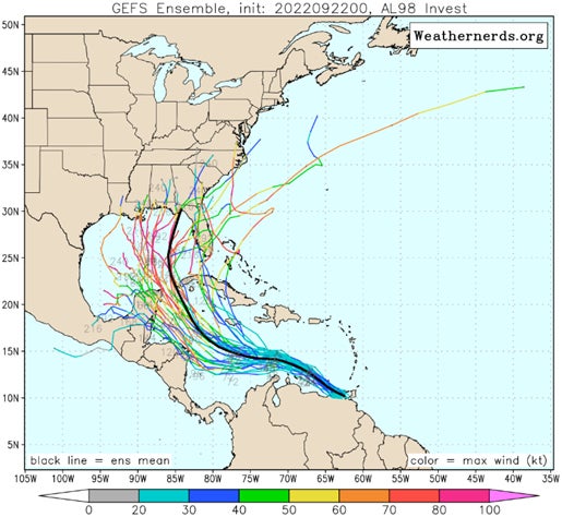
Eyes along the Gulf Coast are looking out to sea this week as an area of concern develops but the uncertainty of its path still remains high.
Emergency Management officials, meteorologists and residents throughout the Gulf region are carefully studying the tropics this week.
Local meteorologist Spinks Megginson is offering some advice as the Invest 98L continues its journey.
“Unfortunately, the uncertainty surrounding INVEST 98L will probably continue in a rather significant way over the next few days until the system gets well-established in the central or western Caribbean Sea,” Megginson said Thursday. “Major weather models typically do not do the best job of nailing down specifics about a tropical system when no low-level center of circulation exists. For now, no low-level center exists. Once the low-level center develops, that is when the system will become a tropical depression or tropical storm. I expect that to happen in 2-3 days when the system is somewhere near or south of Jamaica in the Caribbean Sea. It IS possible that the system becomes a tropical storm a bit sooner than that or later than that, but generally 2-3 days from now is a good estimate of when this system should be a named tropical storm in the Caribbean Sea.”
The key points to keep in mind in the coming days are:
There is high uncertainty about the future track of this system. However, the potential does exist for a hurricane to develop in or near the Gulf of There is high uncertainty about the future track of this system. However, the potential does exist for a hurricane to develop in or near the Gulf of Mexico;
Everyone along the Gulf Coast should remain alert and keep up to date with latest forecasts from a trusted source including the National Hurricane Center, National Weather Service and local Emergency Management. Beware of making critical decisions based on long-range spaghetti plots;
Remember, impacts occur well ahead of landfall, so depending on where the eventual track occurs, they could start sooner than you expect.
The time to make any preparations for possible weather emergencies is now. Check out suggestions for hurricane preparedness at https://www.ready.gov/hurricanes and https://www.weather.gov/wrn/hurricane-preparedness .
For daily updates on weather that has an impact on Escambia County and the surrounding area, be sure to download the RedZone Weather app and follow RedZone Weather on Facebook. You can download the app at redzoneweather.com/app.