Frigid temperatures to hit area Friday, weekend
Published 10:07 am Tuesday, December 20, 2022
Dreams of a white Christmas may not come true this year, but for those who appreciate cold weather, this Christmas weekend will be just the ticket.
Escambia County Emergency Management Director David Adams released information Tuesday concerning the coming frigid weather expected to hit the area on Friday.
“We are expecting some very cold temperatures at the end of the week and through the weekend,” Adams said. “Please prepare accordingly.”
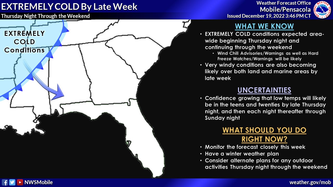
National Weather Service officials in Mobile said the arctic cold front is still expected to move across our area Thursday night into early Friday morning, bringing a sharply colder air mass to the area. Temperatures by Friday morning will be teens and 20s across much of the interior with upper 20s and low 30s near the coast. Strong northwest winds will make it feel much colder with wind chill values in the single digits across northern portions of the area.
High temperatures on Friday will likely stay near, or just below freezing for most areas northwest of I-65 with wind chill values in the teens and 20s for most of the area. In fact, for many locations on Friday the currently forecasted high temperatures for the date (the 23rd), will be among the top 5 coldest daytime max temperatures for that date ever. See the attached graphic for reference.
The coldest temps across the area are expected Friday night, with lows ranging between 10 to 20 degrees north of I-10 and low to mid 20s down to the coast. Wind chill values Friday night into Saturday morning will likely be in the single digits in areas away from the coast.
Similar overnight temperatures are again expected Saturday and Sunday nights, but slightly warmer by a few degrees each night. Daytime highs will be slowly moderating as well, with highs on Saturday mainly in the 30s with 40s along the coast and by Sunday nights warming into the mid-40s to lower 50s across the area.
Adams also encouraged making sure that residents take care to ensure safety from the cold weather for people, pets and plants.
“It’s important that everyone remember the Four Ps for this kind of situation,” Adams said.
• People – dress in layers for the cold if you need to be outside, check on others (especially the elderly) to ensure that they have a way to stay warm and have a safe way to produce heat.
• Pets – be sure pets and other animals have a safe haven to stay warm.
• Plants – move potted plants to a warm area, protect other plants from freezing and frost damage.
• Pipes – be sure to protect pipes from freezing, this will be a holiday weekend and will be difficult to get repair supplies.
“Stay safe, warm and have a Merry Christmas,” Adams said.
Local meteorologist Spinks Megginson said Tuesday that area residents could expect the coldest weather seen in the area in recent years.
“This will be the coldest ‘cold snap’ we have had in many years with most spots expected to have single digit wind chill values (air temps near 15°) by Saturday morning on Christmas Eve,” Megginson reported on Tuesday. “Mostly sunny skies are expected on both Christmas Eve and Christmas Day. High temperatures will be in the mid-30s on Saturday and in the low-40s on Sunday. We note that overnight lows will be in hard freeze territory early on Christmas Eve and on Christmas Day.”