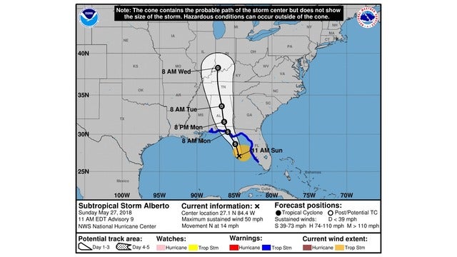
Brewton, Escambia County under Tropical Storm Warning
Published 12:00 pm Sunday, May 27, 2018
Here is the latest information from Escambia County EMA Director David Adams on Alberto.
Note the track has shifted to the east somewhat. If this forecast holds, it reduces the threat to this area somewhat. We are still in the forecast track cone and therefore still have the possibility of severe impacts; so do not let your guard down yet.
The threat of flooding is still significant, as the area to our northeast is still well within the area forecast to receive heavy rainfall.
Escambia County, Ala. has just been placed under a Tropical Storm Warning, details below:
Alberto Local Watch/Warning Statement/Advisory Number 9
National Weather Service Mobile AL AL012018
1144 AM CDT Sun May 27 2018
ALZ059-280045-
/O.EXA.KMOB.TR.W.1001.000000T0000Z-000000T0000Z/
Escambia-
1144 AM CDT Sun May 27 2018
...TROPICAL STORM WARNING IN EFFECT...
A Tropical Storm Warning means tropical storm-force winds are
expected somewhere within this area within the next 36 hours
* LOCATIONS AFFECTED
- Atmore
- Brewton
- Flomaton
* WIND
- LATEST LOCAL FORECAST: Below tropical storm force wind
- Peak Wind Forecast: 10-20 mph with gusts to 30 mph
- POTENTIAL THREAT TO LIFE AND PROPERTY: Potential for wind 58 to
73 mph
- The wind threat has remained nearly steady from the
previous assessment.
- PLAN: Plan for dangerous wind of equivalent strong tropical
storm force due to possible forecast changes in track,
size, or intensity.
- PREPARE: Remaining efforts to protect life and property
should be completed as soon as possible. Prepare for
significant wind damage.
- ACT: Move to safe shelter before the wind becomes hazardous.
- POTENTIAL IMPACTS: Significant
- Some damage to roofing and siding materials, along with
damage to porches, awnings, carports, and sheds. A few
buildings experiencing window, door, and garage door
failures. Mobile homes damaged, especially if unanchored.
Unsecured lightweight objects become dangerous projectiles.
- Several large trees snapped or uprooted, but with greater
numbers in places where trees are shallow rooted. Several
fences and roadway signs blown over.
- Some roads impassable from large debris, and more within
urban or heavily wooded places.
- Scattered power and communications outages, but more
prevalent in areas with above ground lines.
* FLOODING RAIN
- LATEST LOCAL FORECAST: Flash Flood Watch is in effect
- Peak Rainfall Amounts: Additional 2-4 inches, with locally
higher amounts
- POTENTIAL THREAT TO LIFE AND PROPERTY: Potential for moderate
flooding rain
- The flooding rain threat has remained nearly steady from
the previous assessment.
- PLAN: Emergency plans should include the potential for
moderate flooding from heavy rain. Evacuations and rescues
are possible.
- PREPARE: Consider protective actions if you are in an area
vulnerable to flooding.
- ACT: Heed any flood watches and warnings. Failure to take
action may result in serious injury or loss of life.
- POTENTIAL IMPACTS: Significant
- Moderate rainfall flooding may prompt several evacuations
and rescues.
- Rivers and tributaries may quickly become swollen with
swifter currents and overspill their banks in a few places,
especially in usually vulnerable spots. Small streams,
creeks, canals, and ditches overflow.
- Flood waters can enter some structures or weaken
foundations. Several places may experience expanded areas
of rapid inundation at underpasses, low-lying spots, and
poor drainage areas. Some streets and parking lots take on
moving water as storm drains and retention ponds overflow.
Driving conditions become hazardous. Some road and bridge
closures.
* TORNADO
- LATEST LOCAL FORECAST:
- Situation is somewhat favorable for tornadoes
- POTENTIAL THREAT TO LIFE AND PROPERTY: Potential for a few
tornadoes
- The tornado threat has remained nearly steady from the
previous assessment.
- PLAN: Emergency plans should include the potential for a
few tornadoes.
- PREPARE: If your shelter is particularly vulnerable to
tornadoes, prepare to relocate to safe shelter before
hazardous weather arrives.
- ACT: If a tornado warning is issued, be ready to shelter
quickly.
- POTENTIAL IMPACTS: Limited
- The occurrence of isolated tornadoes can hinder the
execution of emergency plans during tropical events.
- A few places may experience tornado damage, along with
power and communications disruptions.
- Locations could realize roofs peeled off buildings,
chimneys toppled, mobile homes pushed off foundations or
overturned, large tree tops and branches snapped off,
shallow-rooted trees knocked over, moving vehicles blown
off roads, and small boats pulled from moorings.


