Winter storm to put area in ‘deep freeze’
Published 4:34 pm Monday, January 15, 2024
|
Getting your Trinity Audio player ready...
|
Weather officials across the state are calling for a “deep freeze” for most residents across Alabama.
For our area in South Alabama, the forecast may be calling for cold temperatures, but weather precipitation shouldn’t be a problem maker.
A Winter Storm Watch has been issued from early Tuesday, according to officials. Winter Weather Advisories are likely farther south in later updates by the National Weather Service (NWS).
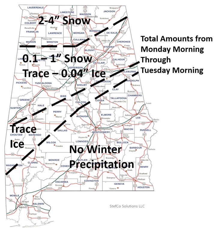
Confidence continues to increase on a winter weather event early next week followed by extremely cold temperatures. However, there is still uncertainty of exactly where the transition of snow to a mixture of rain, freezing drizzle/rain, sleet and snow will occur.
Light snow was expected in northwest Alabama after 12 am Monday, but was expected to end around 6 a.m. on Tuesday with other precipitation across the state expected to be moving out by noon Tuesday.
There will likely be significant travel impacts as a result of the winter storm pushing through the state. The Alabama Department of Transportation’s (ALDOT’s) goal is to keep state, U.S. and interstate highways safe and open. ALDOT’s crews prioritize interstate routes and then other routes by traffic volume.
Motorists are advised to avoid travel if snowy or icy conditions develop. With temperatures expected to remain below freezing across much of Alabama for several days, any moisture on roadways may freeze.
Motorists are urged to monitor weather reports and check road conditions by visiting algotraffic.com or downloading the ALGO traffic app.
Reduce speed as conditions dictate, do not follow other vehicles closely and refrain from sudden braking. State law requires motorists to slow down and move over when approaching highway maintenance crews or first responders at work.
ALDOT maintains state, U.S. and interstate highways. Check with local government agencies for conditions on city or county roads.
Prepare your vehicle by having a full tank of gas and an emergency supply kit containing a phone charger, ice scraper, flashlight, jumper cables, blankets, non-perishable food, bottled water and any other critical supplies.
Cold cold air will begin entering the state Monday with bitterly cold temperatures Monday night through Tuesday.
Here are the forecast temperatures next week:
Monday – Lows from the middle teens north to middle 30s at the coast. The forecast temperatures for the Brewton/East Brewton area are expected reach the freezing mark — 32 degrees — overnight on Monday.
Tuesday – For our coverage area, temperatures a high of around 37 degrees is expected with an overnight low around 16 degrees Tuesday night. Wind chills from single digits to -10.
Wednesday – The high is expected to stay in the 40s with a high of 46 during the day. Wednesday temps will dip down to around the 25 degree mark.
Thursday – Conditions will improve on Thursday with a warm-up to a high of 57 degrees. The overnight low on Thursday should dip down to 36 degrees.
The next system will bring rain to the state Thursday afternoon into Friday morning. There could be a period of mixed winter precipitation north of I-20 before the precipitation ends, but confidence is currently low on any wintry precipitation. This will be followed by another arctic blast of cold air.
High temperatures in our coverage area on Friday will be in the middle 50s at the coast. Lows Friday will be around the middle 20s at coast. Highs Saturday will be in the middle 40s at the coast. Lows will be in the upper 20s at the coast.


